The Finnish company’s first two satellites lifted land-cover accuracy in a Copernicus pilot. Chief executive Jarkko Antila says the next generation, due to launch next year, has far more to give.
Europe has committed to putting restoration measures on a fifth of its land and sea by 2030. Under the Verordnung zur Wiederherstellung der Natur, every member state owed the European Commission a draft national plan by 1 September. Most were late, and 20 countries had not submitted when the deadline passed.
Those plans depend on knowing what is happening on the ground. However, the official maps governments use change slowly. Jarkko Antila, chief executive of Finnish satellite company Kuva Space, said Europe’s official land cover and land use maps “are updated every six years or so”.
“So, you know, if you can do it with a satellite constellation almost daily, you can imagine that it’s way better information for landowners and city planners,” he told the Climate Solutions News podcast.
A pilot built on two small satellites
Kuva Space provides hyperspectral imaging that can close that gap. A normal camera records red, green and blue light. By contrast, a hyperspectral sensor records many narrow bands across the spectrum.
“Instead of just seeing the three colors that you have in a normal camera, red, green, and blue, you see tens or even hundreds of wavelengths,” Antila said. “And they go up to infrared, so not only the visible part.”
Each material absorbs sunlight in its own way, so the readings act as a signature. Antila described the goal as “identifying the kind of material fingerprints that you get when the sun or whatever light gets absorbed by the object”. The company’s AI models then work out what each pixel contains.
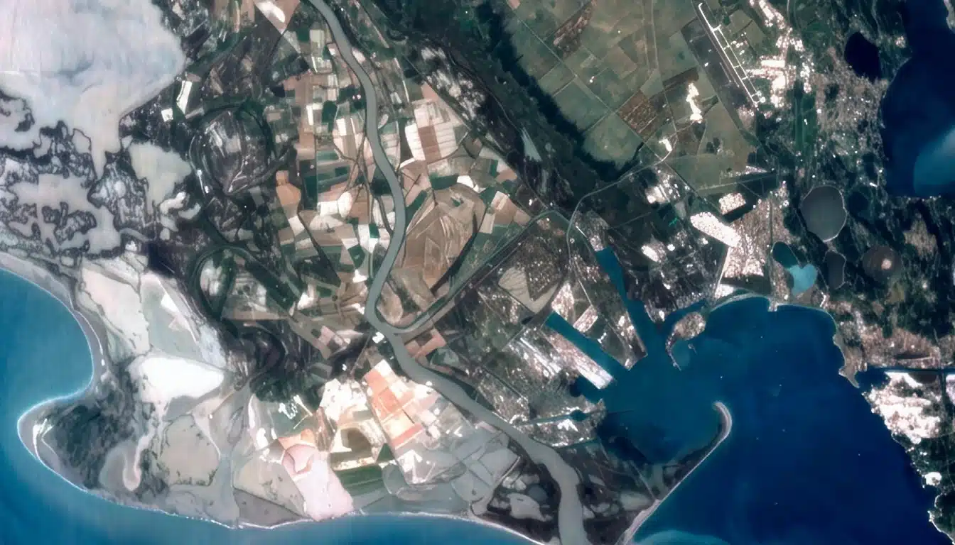
Kuva put that approach to work in a pilot under the Copernicus Contributing Missions programme, published on 28 October. It combined data from its two Hyperfield-1 satellites with imagery from ESA’s Sentinel-2. Between June 2025 and May 2026, Hyperfield-1 collected 98 images covering about 90,000 km². They spanned five areas in Greece, Romania, France, the UK and Russia. Kuva checked the results against land cover mapped by hand from very high resolution imagery. In three areas, the combined model reached nearly 70 per cent accuracy. Each source alone scored about 68 per cent, and ESA’s WorldCover product scored 66.7 per cent.
The pairing also handled cloud. When one input was cloudy, the model leaned on the clearer source, so that day’s map had no gaps. Both satellites met the pilot’s data-quality targets and gave consistent results with each other. Checked against the RadCalNet calibration network, surface-reflectance error was 2.4 and 3.0 per cent, inside a ceiling of 10 per cent.
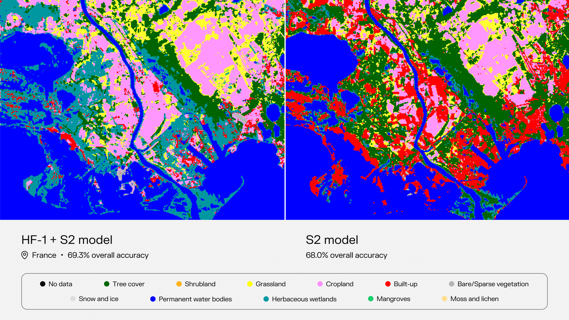
Comparison of accuracy of the combined technology vs S2 only.
Why a two-point gain is just the start
On its face, two percentage points is a modest improvement. Antila accepts that, and points to the hardware behind it.
“That doesn’t sound like a big leap, but we have now our first two Hyperfield satellites, which are still our first generation satellites, and they don’t go up in infrared wavelengths that much yet,” he said.
The first satellites leave part of the spectrum unused, so the pilot measured a limited instrument. Antila called the result “a really good proof of concept that even with this kind of limited technology that we now have, we can already improve” on Sentinel-2 results.
“There’s certainly way more room to improve with our second generation satellites in the future,” he said.
Those satellites are coming soon. Kuva has six second-generation Hyperfield-2 satellites in the pipeline, as Antila explained: “We are launching two first satellites next year.” They add short-wave infrared and higher-resolution colour imagery. Both are designed to separate snow, built-up areas, bare soil and shrubs, which current systems still confuse.
The new satellites will also process data in orbit.
“We’ll be running our foundation model in the satellite itself so we can send these warnings to customers if we detect something suspicious on whatever topic in about fifteen minutes from the detection wherever it is in the world,” Antila said.
From maps to a data service
For governments drawing up restoration plans, Kuva wants to supply finished maps instead of raw imagery. “Our services are aimed to deliver more or less continuous information on the land cover land use and inform about its changes,” Antila said. He described the output as “decision making ready information”.
Governments come first, but the company is also courting agribusiness, traders, insurers and firms with supply-chain reporting duties. “It starts from governmental and also moves then gradually more and more to the private sector,” he said.
Customers would draw data through an API or a dashboard, without tasking satellites themselves. “Our goal is to reach a status where the customers don’t even think that we are a space company,” Antila said. “They just want the information and space is the means for us to deliver that information.”
Defence work on the same data
The same imagery also serves security customers. Kuva has detected unregistered “dark” vessels and, in a separate pilot, opium poppy fields in Afghanistan.
“Hyperspectral is a multi-use piece of data,” Antila said. One scene can contain forests, farmland, roads and camouflage nets, and “we can detect all of them from applying different algorithms to the same raw data”.
Defence has grown over the past four or five years, he said, mostly in Europe. Still, the company’s roots lie in farming and environmental monitoring, and “the agri environment hasn’t gone anywhere”.
Room alongside ESA’s own mission
ESA is building its own hyperspectral satellite, CHIME, as one of the Copernicus expansion missions. Antila sees it as a partner, because the two systems revisit the Earth at very different rates.
A commercial constellation could watch the planet “two, three times a day”, he said, whereas a single large satellite may return to a spot every week or two.
In cost terms, “half of the constellation is probably the same price as one of the CHIMEs”. As a result, Kuva expects to use CHIME data for cross-calibration and to fill wavelength gaps. “We see that as an addition to this hyperspectral world,” he said.
Funding for the next phase
Building a constellation takes capital. Kuva closed a €16.6m Series A in 2023, and Antila put the total raised to date at about €40m.
“With that we’ve launched five satellites in total and we have the first six of the generation two satellites in the pipeline,” he said. Commercial contracts worth several million euros mean the company is not under pressure, he added, but it is preparing a new raise. “We’re getting ready to, you know, start really scaling.”
Kuva aims for sub-daily global coverage by the end of 2030. “With 70+ Hyperfield satellites in orbit by the end of the decade, we will improve not only accuracy but also temporal coverage of land cover mapping and land cover changes globally,” said Tuomas Tikka, the company’s chief strategy officer.
International deals support that plan. Kuva’s US arm joined NASA’s Commercial Satellite Data Acquisition programme in July. That month it also signed an agreement with Japan’s IHI on a possible Japanese constellation. “We’re actually the only hyperspectral company that is both in the EU Copernicus and the NASA CSDA programs,” Antila said.
What the second generation has to show
Europe’s restoration deadline is now a little over three years away. Meanwhile, member states still have to show where restoration is happening and whether it works.
Kuva’s pilot showed two first-generation satellites could improve on the maps Europe already uses. The Hyperfield-2 launches next year will show how far a fuller spectrum, and many more satellites, can take that gain.